Vancouver, British Columbia–(Newsfile Corp. – September 9, 2021) – Goldshore Resources Inc. (TSXV: GSHR) (OTCQB: GSHRF) (FWB: 8X00) (“Goldshore” or the “Company“), is pleased to announce that it has received the initial magnetic images from the heli-borne Versatile Time-Domain Electromagnetic (VTEM™ Plus) and Horizontal Magnetic Gradiometer geophysical survey conducted by Geotech Ltd. (“Geotech”) on the Moss Lake Gold Project located in northwest Ontario (Figure 1).
Highlights:
- Geotech’s processed magnetic images highlight the regional-scale attenuation, asymmetric boudinage and anastomosing character of shear zones, which are conducive for similar-scale fluid flow systems and speak to the prospectivity for mineralization in the district;
- The data allows the mapping of tightly folded stratigraphic units and intrusion margins, which correlate with gold mineralization and provide additional targets for drill testing;
- The data also highlight late NNE-striking sinistral strike slip faults that truncate the Moss Lake gold deposit and suggest a potential extension of mineralization in an area that has been significantly under-drilled; and
- The structurally controlled NE-trending domain boundary between highly magnetic and weakly magnetic rocks along the eastern flank of the Company’s tenement is the focus of high-grade copper-gold mineralization in the Hamlin prospect (IOCG) and the North Coldstream mine (VMS).
Peter Flindell, VP Exploration commented, “We are delighted to receive this excellent quality dataset that provides significant insight into the structural complexity of our portion of the Shebandowan Greenstone Belt. At this early stage, it suggests both potential offsets of, and focusing mechanisms for, mineralization. This information will greatly assist our efforts to generate new targets and prioritize our drilling program.”
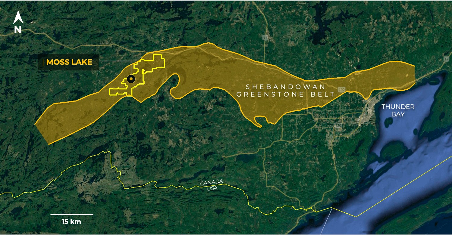
Figure 1: Location map showing Goldshore’s Moss Lake Project relative to the Shebandowan Greenstone Belt
To view an enhanced version of Figure 1, please visit:
https://orders.newsfilecorp.com/files/8051/95957_fbe858b0444da85d_002full.jpg
Technical Overview
In July 2021, Geotech completed a 2,080-line kilometer heliborne VTEM and magnetic survey on a 100-metre line spacing over the entire tenement, and a 50-metre line spacing over the areas of known mineralization at Moss Lake, Coldstream, and Hamlin. The sensor was maintained at a nominal drape height of 30 meters. The details of this survey are described in the Goldshore press release dated July 14, 2021.
Goldshore technical staff have conducted a preliminary review of the recently received magnetic imagery ahead of a more detailed study being undertaken by TechnoImaging LLC, of Salt Lake City, Utah; which will include 3D inversions of the entire magnetic and VTEM data. TechnoImaging will produce a more qualified and detailed geological interpretation together with constrained 3D targets for follow up exploration.
As part of Goldshore’s review, the Company commenced with the Total Magnetic Intensity (“TMI”) image available from the OGSEarth website curated by Ontario’s Ministry of Northern Development, Mines, Natural Resources and Forestry (Figure 2). This is a composite of several historic kilometer-scale surveys. It shows the Shebandowan Greenstone Belt to be structurally complex with multiple sigmoidal magnetic trends defined by anastomosing shears and attenuated, lenticular, rigid bodies, which attests to the high degree of non-axial shearing. Furthermore, the presence of boudinaged rigid bodies in the high strain zones provides for markedly different strain responses that can be important for producing and maintaining a permeability network for mineralizing fluids. These rigid bodies include highly magnetic mafic intrusions and low magnetic granitic intrusions, while the highly sheared rocks are a sequence of felsic, intermediate and mafic volcanic rocks together with minor sedimentary units.
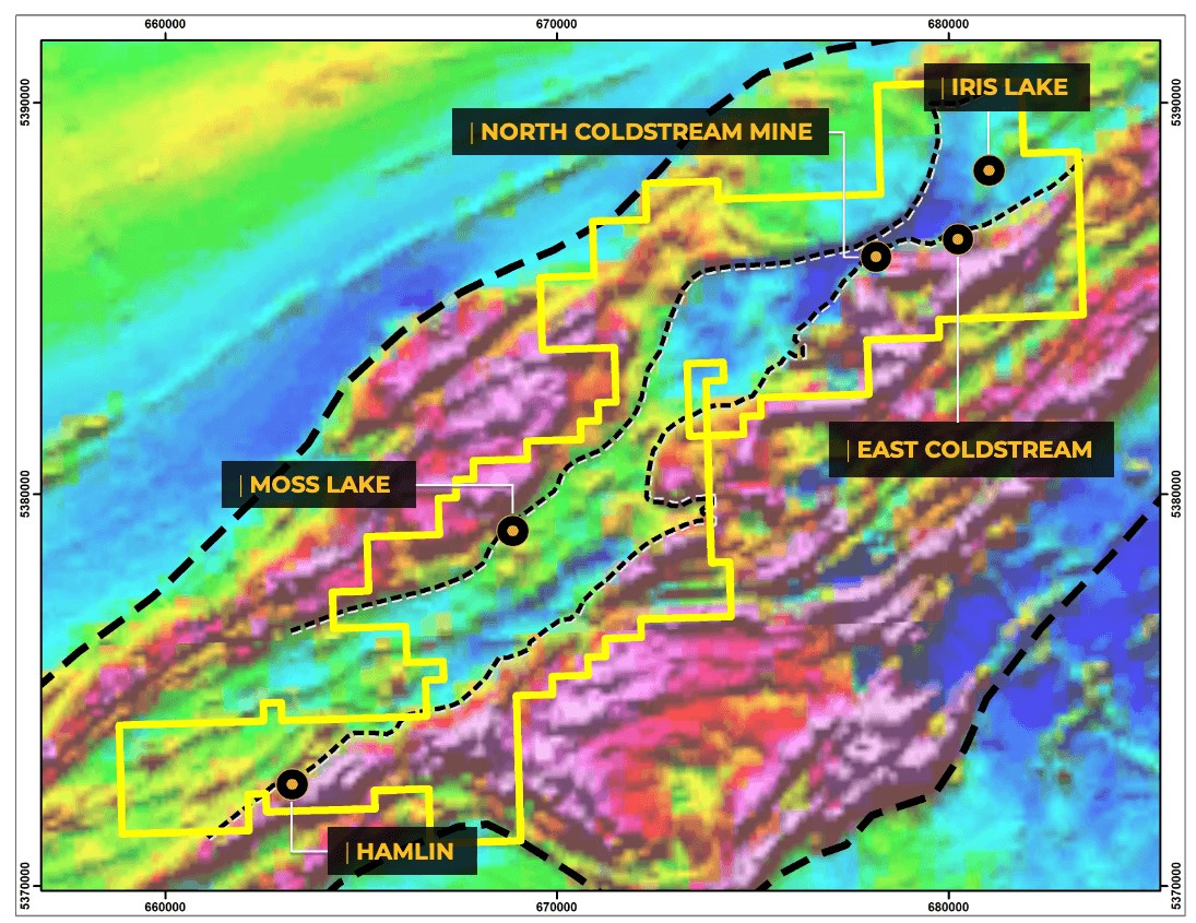
Figure 2: Goldshore’s Moss Lake Project and known prospects relative to the Shebandowan Greenstone Belt (as defined by the OGSEarth TMI image) together with identified magnetic domains showing the complex anastomosing shears and asymmetric boudinaged bodies.
To view an enhanced version of Figure 2, please visit:
https://orders.newsfilecorp.com/files/8051/95957_fbe858b0444da85d_003full.jpg
The Geotech TMI image (Figure 3) overlays extremely well with the regional TMI image giving high confidence in the validity of both datasets as a tool for geological interpretation. The detailed TMI image shows two domains of high magnetic intensity along a NE-SW axis representing mafic intrusions and volcanic rocks along the southeast and northwest margin of the Moss Lake Gold Project. The central NE-striking band of lower magnetic character through the core of the Moss Lake Gold Project reflects the sheared sequence of felsic – intermediate volcanic rocks and sedimentary units together with smaller, presumably also boudinaged, intrusions.

Figure 3: Detailed Total Magnetic Intensity image from Geotech showing the known prospects relative to the main magnetic domains
To view an enhanced version of Figure 3, please visit:
https://orders.newsfilecorp.com/files/8051/95957_fbe858b0444da85d_004full.jpg
While the structures shown in the TMI image (Figure 2) reflect the regional-scale attenuation within the greenstone belt, the more processed Tilt Derivative (“TD”) image (Figure 3) shows a high degree of geological detail. The TD image, which combines the approach taken in more traditional vertical derivative and horizontal gradient images, emphasizes changes in magnetic signature rather than absolute magnetic intensity.
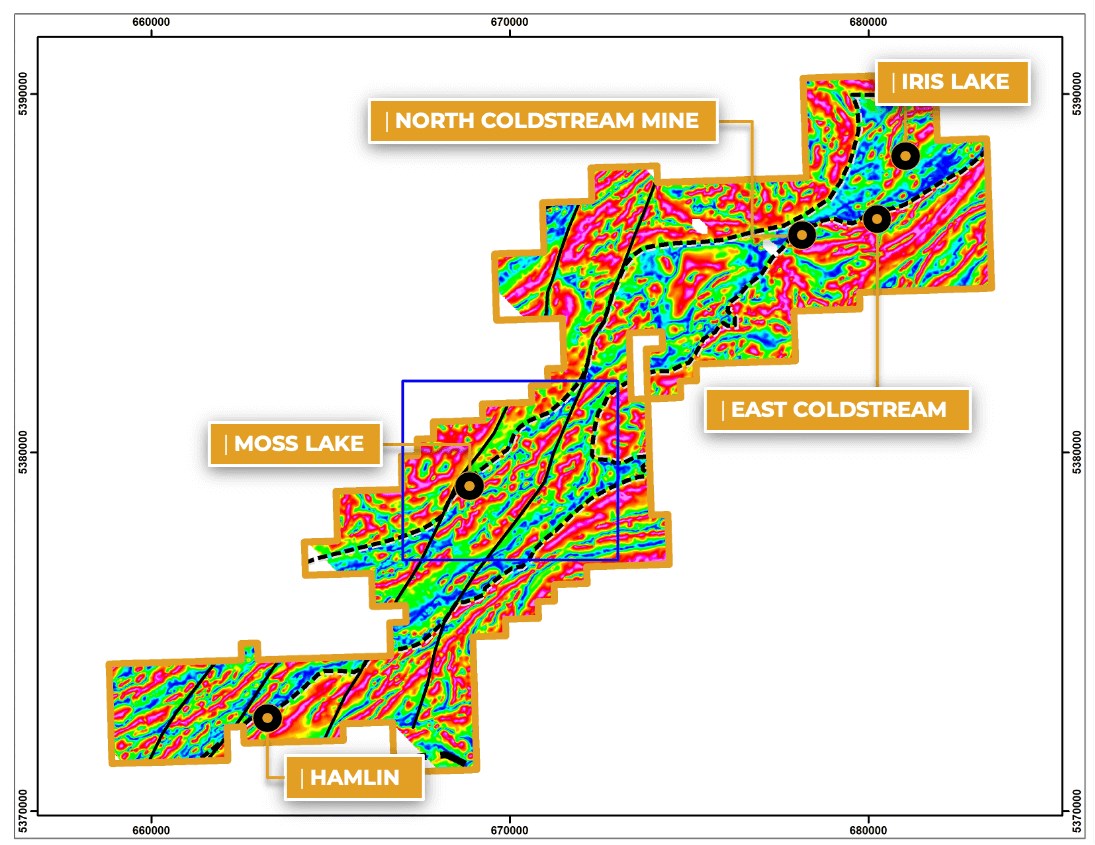
Figure 4: Tilt Derivative image from Geotech showing the greater geological detail than can be mapped by the detailed magnetic survey data. This includes NNE-striking strike-slip faults and tightly folded bodies indicated by contorted red colours. The inset box refers to the location of Figure 5.
To view an enhanced version of Figure 4, please visit:
https://orders.newsfilecorp.com/files/8051/95957_fbe858b0444da85d_005full.jpg
The TD image shows better definition of the domain boundaries shown in Figure 3 and hints at significant and multiple tight folding events that can result in progressive repartitioning of fluid flow and maintenance of permeability networks over significant time. This speaks to the prospectivity of the geology within Goldshore’s land package.
The image also maps late NNE-striking faults, which offset the structurally complex stratigraphy.
Figure 5 is an inset of the area around the Moss Lake gold deposit. It shows the detail that may not be obvious in the larger image (Figure 4), including the multiply folded geometry and the association of gold grades with the edges of magnetic and non-magnetic bodies. Figure 5 also shows areas where the Company may expect to discover additional mineralization as extensions of the historical resource.

Figure 5: Detailed view of the Moss Lake gold deposit showing the Company’s preliminary interpretation, gold assays above 0.5 g/t Au in historic drill holes and new target areas. The latter include the following short term priorities: A – immediate southwest extension to Moss Lake; B – faulted offset extension to Moss Lake; C and D – northeast strike extensions to Moss Lake Main Zone; and E – potential mineralization in a parallel zone. Potential exists in many other similar, but not yet defined settings.
To view an enhanced version of Figure 5, please visit:
https://orders.newsfilecorp.com/files/8051/95957_fbe858b0444da85d_006full.jpg
The Company’s preliminary observations include:
- Domain boundaries between mafic dominated and felsic dominated stratigraphic and intrusive rocks are clearly major fault zones across which there are high gradients in shearing strain (Figures 2 and 3);
- The known high-grade copper-gold projects at Hamlin and the North Coldstream mine lie along the eastern NE-trending domain boundary (Figures 2-4);
- The late NNE-trending faults are interpreted as sinistral strike-slip structures (Figure 4);
- The high-grade Iris Lake prospect appears to be localized in a fold nose (Figures 3 and 4);
- One of the late NNE-striking faults truncates the western margin of the Moss Lake gold deposit raising the potential for the discovery of the extension of this deposit on the other side of the fault. Current information suggests that the extension likely occurs to the southwest in an area that has been drilled by only two holes by the previous explorers, which did intersect gold mineralization (Figure 5);
- Isoclinal folding and boudinaging in shear zones points to the much greater structural complexity of the Shebandowan Greenstone Belt, suggesting that a greater number of structurally localized mineralized areas may await discovery (Figures 4 and 5); and
- Gold mineralization at the Moss Lake gold deposit occurs along the flanks of magnetic bodies. Several potential extensions to mineralization at the deposit scale are indicated on Figure 5.
Goldshore is confident that a closer review of these magnetic data over the whole tenement, together with historic prospecting datasets that are yet to benefit from this valuable geological context, will generate many more prospect candidates for future drill testing.
The Company awaits the final VTEM imagery, which will highlight the distribution of conductive units across the project. These are generally concentrations of sulphide mineralization that should correlate with our high-grade copper-gold targets, but may also include graphite-rich stratigraphic units. Work by TechnoImaging will allow us to discriminate these anomaly sources. The nature of these conductors will map the extent of the known mineralization, while any additional conductors will be new and previously undiscovered targets.
“The first results received, while only a small part of the entire package we will ultimately receive from Geotech and TechnoImaging, highlight the importance and benefits of conducting a detailed project-wide geophysical survey. We can already test discrete new targets and extensions to gold mineralization at Moss Lake; and start to prepare for testing the copper-gold and gold targets at Hamlin, Iris and North and East Coldstream,” commented Brett Richards, President and Chief Executive Officer of Goldshore.
About Tilt Derivative Magnetics
The Tilt Derivative (“TD”) is a function of the ratio of the vertical and horizontal derivatives of the magnetic field intensity. The peaks of tilt angle amplitude should be located over the center and its zeros over the edges of the source body. The tilt angle method is used to investigate the boundaries of deep and shallow structures and provides considerably more fine detail than the standard processed products.
About Goldshore
Goldshore is an emerging junior gold development company, and owns the Moss Lake Gold Project located in Ontario. Wesdome Gold Mines Ltd. is currently a strategic shareholder of Goldshore with an approximate 30% equity position in the Company. Well-financed and supported by an industry-leading management group, board of directors and advisory board, Goldshore is positioned to advance the Moss Lake Gold Project through the next stages of exploration and development.
About the Moss Lake Gold Project
The Moss Lake Gold Project is located approximately 100 km west of the city of Thunder Bay, Ontario. It is accessed via Highway 11 which passes within 1 km of the property boundary to the north. The Moss Lake Gold Project covers 14,292 hectares and consists of 282 unpatented and patented mining claims.
Moss Lake hosts a number of gold and base metal rich deposits including the Moss Lake Deposit, the East Coldstream Deposit (Table 1), the historically producing North Coldstream Mine (Table 2), and the Hamlin Zone, all of which occur over a mineralized trend exceeding 20 km in length. A historical preliminary economic assessment was completed on Moss Lake in 2013 and published by Moss Lake Gold1. A historical mineral resource estimate was completed on the East Coldstream Deposit in 2011 by Foundation Resources Inc2,3. In addition to these zones, the Moss Lake Gold Project also hosts a number of under-explored mineral occurrences which are reported to exist both at surface and in historically drilled holes. The Moss Lake Deposit is a shear-hosted disseminated-style gold deposit which outcrops at surface. It has been drilled over a 2.5 km length and to depths of 300 m with 376 holes completed between 1983 and 2017. The last drilling program conducted in 2016 and 2017 by Wesdome Gold Mines Ltd. (“Wesdome“), which consisted of widely spaced holes along the strike extension of the deposit was successful in expanding the mineralized footprint and hydrothermal system 1.6 km to the northeast. Additionally, the deposit remains largely open to depth. In 2017, Wesdome completed an induced polarization survey which traced the potential extensions of pyrite mineralization associated with the Moss Lake Deposit over a total strike length of 8 km and spanning the entire extent of the survey grids.
The East Coldstream Deposit is a shear-hosted disseminated-style gold deposit which locally outcrops at surface. It has been drilled over a 1.3 km length and to depths of 200 m with 138 holes completed between 1988 and 2017. The deposit remains largely open at depth and may have the potential for expansion along strike. Historic drill hole highlights from the East Coldstream Deposit include 4.86 g/t Au over 27.3 m in C-10-15 from previous / historical exploration.
The historically producing North Coldstream Mine is reported to have produced significant amounts of copper, gold and silver4from mineralization with potential iron-oxide-copper-gold deposit style affinity. The exploration potential immediately surrounding the historic mining area is not currently well understood and historic data compilation is required.
The Hamlin Zone is a significant occurrence of copper and gold mineralization, and also of potential iron-oxide-copper-gold deposit style affinity. Between 2008 and 2011, Glencore tested Hamlin with 24 drill holes which successfully outlined a broad and intermittently mineralized zone over a strike length of 900 m. Historic drill hole highlights from the Hamlin Zone include 0.9 g/t Au and 0.35% Cu over 150.7 m in HAM-11-75.
The Moss Lake, East Coldstream and North Coldstream deposits sit on a mineral trend marked by a regionally significant deformation zone locally referred to as the Wawiag Fault Zone in the area of the Moss Lake Deposit. This deformation zone occurs over a length of approximately 20 km on the Moss Lake Gold Project and there is an area spanning approximately 7 km between the Moss Lake and East Coldstream deposits that is significantly underexplored.
Table 1: Historical Mineral Resources1,2,3
| INDICATED | INFERRED | |||||
| Deposit | Tonnes | Au g/t | Au oz | Tonnes | Au g/t | Au oz |
| Moss Lake Deposit1 (2013 resource estimate) | ||||||
| Open Pit Potential | 39,795,000 | 1.1 | 1,377,300 | 48,904,000 | 1.0 | 1,616,300 |
| Underground Potential | – | – | – | 1,461,100 | 2.9 | 135,400 |
| Moss Lake Total | 39,795,000 | 1.1 | 1,377,300 | 50,364,000 | 1.1 | 1,751,600 |
| East Coldstream Deposit2 (2011 resource estimate) | ||||||
| East Coldstream Total | 3,516,700 | 0.85 | 96,400 | 30,533,000 | 0.78 | 763,276 |
| Combined Total | 43,311,700 | 1.08 | 1,473,700 | 80,897,000 | 0.98 | 2,514,876 |
Notes:
- (Source: Poirier, S., Patrick, G.A., Richard, P.L., and Palich, J., 2013. Technical Report and Preliminary Economic Assessment for the Moss Lake Project, 43-101 technical report prepared for Moss Lake Gold Mines Ltd. Moss Lake Deposit resource estimate is based on 0.5 g/t Au cut-off grade for open pit and 2.0 g/t Au cut-off grade for underground resources.
- Source: McCracken, T., 2011. Technical Report and Resource Estimate on the Osmani Gold Deposit, Coldstream Property, Northwestern Ontario, 43-101 technical report prepared for Foundation Resources Inc. and Alto Ventures Ltd. East Coldstream Deposit resource estimate is based on a 0.4 g/t Au cut-off grade.
- The reader is cautioned that the above referenced “historical mineral resource” estimates are considered historical in nature and as such is based on prior data and reports prepared by previous property owners. A qualified person has not done sufficient work to classify the historical estimates as current resources and Goldshore is not treating the historical estimates as current resources. Significant data compilation, re-drilling, re-sampling and data verification may be required by a qualified person before the historical estimate on the Moss Lake Gold Project can be classified as a current resource. There can be no assurance that any of the historical mineral resources, in whole or in part, will ever become economically viable. In addition, mineral resources are not mineral reserves and do not have demonstrated economic viability. Even if classified as a current resource, there is no certainty as to whether further exploration will result in any inferred mineral resources being upgraded to an indicated or measured mineral resource category.
Table 2: Reported Historical Production from the North Coldstream Deposit4
| Deposit | Tonnes | Cu % | Au g/t | Ag | Cu lbs | Au oz | Ag oz |
| Historical Production | 2,700,0000 | 1.89 | 0.56 | 5.59 | 102,000,000 | 44,000 | 440,000 |
Note:
- Source: Schlanka, R., 1969. Copper, Nickel, Lead and Zinc Deposits of Ontario, Mineral Resources Circular No. 12, Ontario Geological Survey, pp. 314-316.
Peter Flindell, MAusIMM, MAIG , Vice President, Exploration of the Company, a qualified person under NI 43-101, has approved the scientific and technical information contained in this news release.
Neither the TSXV nor its Regulation Services Provider (as that term is defined in the policies of the TSXV) accepts responsibility for the adequacy or accuracy of this release.
For More Information – Please Contact:
Brett A. Richards
President, Chief Executive Officer and Director
Goldshore Resources Inc.
P. +1 604 288 4416
M. +1 905 449 1500
E. brichards@goldshoreresources.com
W. www.goldshoreresources.com
Facebook: GoldShoreRes | Twitter: GoldShoreRes | LinkedIn: goldshoreres
Cautionary Note Regarding Forward-Looking Statements
This news release contains statements that constitute “forward-looking statements.” Such forward-looking statements involve known and unknown risks, uncertainties and other factors that may cause the Company’s actual results, performance or achievements, or developments to differ materially from the anticipated results, performance or achievements expressed or implied by such forward-looking statements. Forward-looking statements are statements that are not historical facts and are generally, but not always, identified by the words “expects,” “plans,” “anticipates,” “believes,” “intends,” “estimates,” “projects,” “potential” and similar expressions, or that events or conditions “will,” “would,” “may,” “could” or “should” occur.
Forward-looking statements in this news release include, among others, statements relating to expectations regarding the exploration and development of the Moss Lake Gold Project, including planned drilling activities and testing of targets, and other statements that are not historical facts. By their nature, forward-looking statements involve known and unknown risks, uncertainties and other factors which may cause our actual results, performance or achievements, or other future events, to be materially different from any future results, performance or achievements expressed or implied by such forward-looking statements. Such factors and risks include, among others: the Company may require additional financing from time to time in order to continue its operations which may not be available when needed or on acceptable terms and conditions acceptable; compliance with extensive government regulation; domestic and foreign laws and regulations could adversely affect the Company’s business and results of operations; the stock markets have experienced volatility that often has been unrelated to the performance of companies and these fluctuations may adversely affect the price of the Company’s securities, regardless of its operating performance; and the impact of COVID-19.
The forward-looking information contained in this news release represents the expectations of the Company as of the date of this news release and, accordingly, is subject to change after such date. Readers should not place undue importance on forward-looking information and should not rely upon this information as of any other date. The Company undertakes no obligation to update these forward-looking statements in the event that management’s beliefs, estimates or opinions, or other factors, should change.
This news release does not constitute an offer to sell, or a solicitation of an offer to buy, any securities in the United States. The securities have not been and will not be registered under the United States Securities Act of 1933, as amended (the “U.S. Securities Act”) or any state securities laws and may not be offered or sold within the United States or to U.S. Persons unless registered under the U.S. Securities Act and applicable state securities laws or an exemption from such registration is available.